< Back to North-South Corridor Overview
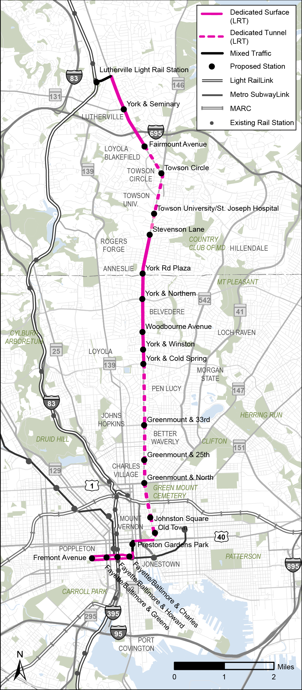
Alternative 1
Light Rail Transit from Lutherville to University of Maryland Medical Center (UMMC) via York Road/Greenmount Avenue
DESCRIPTION
Alternative 1 is a Light Rail Transit (LRT) line between the Lutherville Light Rail Station and University of Maryland Medical Center (UMMC) via Downtown Towson, Waverly, and Old Town. This alignment begins in Lutherville, travels through Towson on York Road, continuing south on York Road and Greenmount Avenue, takes the Orleans Street bridge to connect to St. Paul Street, and concludes in Downtown Baltimore at UMMC. This alternative travels on surface streets and below-grade tunnel and operates almost exclusively in dedicated guideway, with tunnels from Fairmount Avenue to Stevenson Lane and from Cold Spring Lane to Ensor Street.
Key Characteristics
 |
Light Rail Transit |
 |
11.6 miles |
 |
21 stations |
 |
Provides service between Lutherville and UMMC in Downtown Baltimore |
 |
Similar alignment to Alternative 2 (BRT) and the existing CityLink Red bus route |
 |
Highest number of future jobs accessible by transit within 45 minutes for households in the corridor |
Areas Served
 |
Lutherville |
|
Towson |
|
Towson University/St. Joseph's Med. Ctr |
 |
Hillendale |
|
Belvedere Square |
|
Govans |
|
Good Samaritan Hospital |
|
Northwood |
|
Waverly |
|
Johns Hopkins University |
|
North & Greenmount |
|
Penn Station |
|
Midtown/UB |
|
Old Town |
|
Mt. Vernon |
|
Charles Center |
|
University of Maryland Medical Center |
|
Inner Harbor |
|
Harbor East |
|
Port Covington |
|
Theme |
Measure of Effectiveness |
Values |
Comparison |
|
Reliability |
Percent of dedicated or separated guideway |
96% |
GOOD |
|
Fixed or Flexible Guideway |
FIXED |
FIXED |
|
|
Travel Time Savings |
Transit travel time savings between Towson and Downtown Baltimore (minutes) |
11 |
BEST |
|
Access |
Households within 1/2 mile of a station, per mile |
3,700 |
BETTER |
|
Student population within 1/2 mile of a station per mile |
1,100 |
BETTER |
|
|
Future jobs within 1/2 mile of a station per mile |
20,200 |
BETTER |
|
|
Connections |
Connections to rail stations, frequent bus routes, and locally operated transit routes |
23 |
BETTER |
|
Additional future jobs accessible by transit within 45 minutes |
38,000 |
BEST |
|
|
Equity 1 |
All transit-critical populations within 1/2 mile of a station, per mile |
11,400 |
BETTER |
|
Cost |
Capital cost ($ millions) |
4,000 |
$$$ |
|
Development Opportunity |
Transit-Oriented Development and Opportunity Zones within 1/2 mile of station (acres) |
1,200 |
BETTER |
|
Implementation |
Implementation time (years) |
7-9 |
MIDDLE |
|
Bridge and Tunnel Complexity |
Medium |
MEDIUM |
|
|
Ridership |
Projected daily boardings in 2045, per mile |
1,700 |
BETTER |
|
Sustainability |
Zero-car households within ½ mile of a station, per mile |
1,200 |
BETTER |
1 Sum of low-income, minority, limited English proficiency, and 65+ populations, people with disabilities, and zero-car households within 1/2 mile of a station, per mile. People/households may be counted more than once if they're part of multiple transit-critical groups.
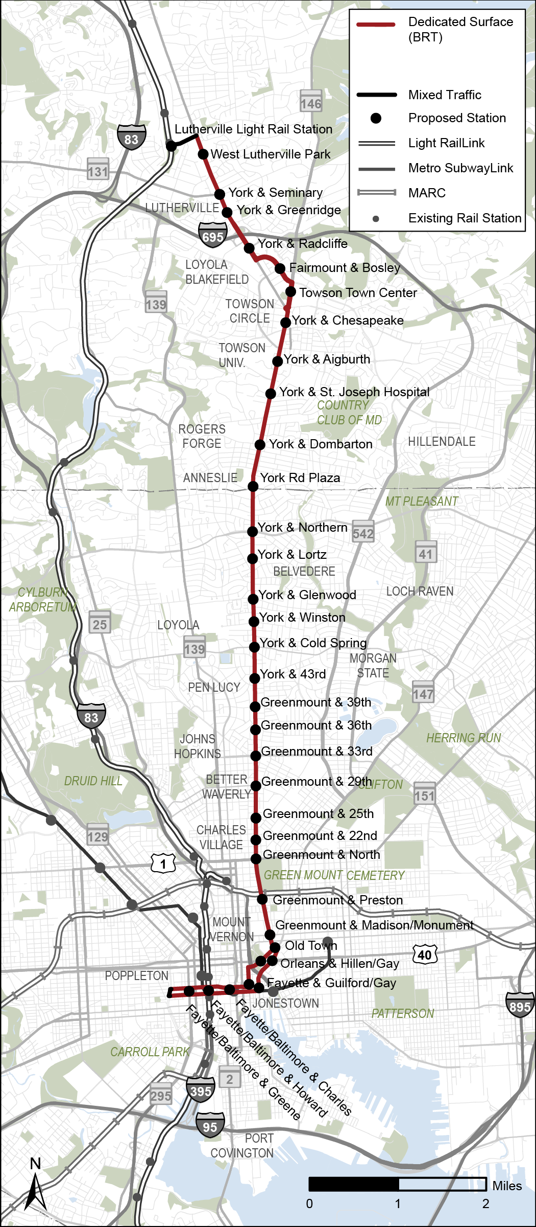
Alternative 2
Bus Rapid Transit from Lutherville to University of Maryland Medical Center (UMMC) via York Road/Greenmount Avenue
DESCRIPTION
Alternative 2 is a Bus Rapid Transit (BRT) line between the Lutherville Light Rail Station and University of Maryland Medical Center (UMMC) via Downtown Towson, Waverly, and Old Town. This alignment begins in Lutherville, travels through Towson on York Road, continues south on York Road and Greenmount Avenue to Hillen and Gay Streets, and concludes in Downtown Baltimore UMMC. This alternative travels on surface streets and operates almost exclusively in dedicated guideway, with mixed traffic between the Lutherville Light Rail Station to York Road (on Ridgely Road) and a short segment on Martin Luther King Jr. Boulevard.
Key Characteristics
|
Bus Rapid Transit |
|
11.5 miles |
|
33 stations |
|
Similar alignment to Alternative 1 (LRT) and the existing CityLink Red bus route |
Areas Served
|
Lutherville |
|
Towson |
|
Towson University/St. Joseph's Med. Ctr |
|
Hillendale |
|
Belvedere Square |
|
Govans |
|
Good Samaritan Hospital |
|
Northwood |
|
Waverly |
|
Johns Hopkins University |
|
North & Greenmount |
|
Penn Station |
|
Midtown/UB |
|
Old Town |
|
Mt. Vernon |
|
Charles Center |
|
University of Maryland Medical Center |
|
Inner Harbor |
|
Harbor East |
|
Port Covington |
|
Theme |
Measure of Effectiveness |
Values |
Comparison |
|
Reliability |
Percent of dedicated or separated guideway |
97% |
BETTER |
|
Fixed or Flexible Guideway |
FLEXIBLE |
FLEXIBLE |
|
|
Travel Time Savings |
Transit travel time savings between Towson and Downtown Baltimore (minutes) |
7 |
BETTER |
|
Access |
Households within 1/2 mile of a station, per mile |
3,800 |
BETTER |
|
Student population within 1/2 mile of a station per mile |
1,100 |
BETTER |
|
|
Future jobs within 1/2 mile of a station per mile |
20,900 |
BEST |
|
|
Connections |
Connections to rail stations, frequent bus routes, and locally operated transit routes |
24 |
BEST |
|
Additional future jobs accessible by transit within 45 minutes |
26,000 |
BETTER |
|
|
Equity 1 |
All transit-critical populations within 1/2 mile of a station, per mile |
11,800 |
BETTER |
|
Cost |
Capital cost ($ millions) |
600 |
$ |
|
Development Opportunity |
Transit-Oriented Development and Opportunity Zones within 1/2 mile of station (acres) |
1,100 |
GOOD |
|
Implementation |
Implementation time (years) |
6-8 |
SHORTEST |
|
Bridge and Tunnel Complexity |
N/A |
N/A |
|
|
Ridership |
Projected daily boardings in 2045, per mile |
1,800 |
BETTER |
|
Sustainability |
Zero-car households within ½ mile of a station, per mile |
1,200 |
BETTER |
1 Sum of low-income, minority, limited English proficiency, and 65+ populations, people with disabilities, and zero-car households within 1/2 mile of a station, per mile. People/households may be counted more than once if they're part of multiple transit-critical groups.
Alternative 3
Bus Rapid Transit from Towson to Harbor East, via York Road/ Greenmount Avenue
DESCRIPTION
Alternative 3 is a Bus Rapid Transit (BRT) line between Towson and the Inner Harbor via York Road and St. Paul Street. The alignment begins in Towson, travels on York Road and Greenmount Avenue before turning west to merge with St. Paul Street. At Pratt Street it turns southeast before concluding at Harbor East. This alternative travels entirely on surface streets and operates exclusively in dedicated guideway.
Key Characteristics
|
Bus Rapid Transit |
|
9.2 miles |
|
28 stations |
 |
Provides the greatest access to transit-critical populations per mile, students per mile, and jobs per mile |
 |
Lowest total Capital Cost |
Areas Served
|
Lutherville |
|
Towson |
|
Towson University/St. Joseph's Med. Ctr |
|
Hillendale |
|
Belvedere Square |
|
Govans |
|
Good Samaritan Hospital |
|
Northwood |
|
Waverly |
|
Johns Hopkins University |
|
North & Greenmount |
|
Penn Station |
|
Midtown/UB |
|
Old Town |
|
Mt. Vernon |
|
Charles Center |
|
University of Maryland Medical Center |
|
Inner Harbor |
|
Harbor East |
|
Port Covington |
|
Theme |
Measure of Effectiveness |
Values |
Comparison |
|
Reliability |
Percent of dedicated or separated guideway |
98% |
BETTER |
|
Fixed or Flexible Guideway |
FLEXIBLE |
FLEXIBLE |
|
|
Travel Time Savings |
Transit travel time savings between Towson and Downtown Baltimore (minutes) |
7 |
BETTER |
|
Access |
Households within 1/2 mile of a station, per mile |
4,700 |
BEST |
|
Student population within 1/2 mile of a station per mile |
1,200 |
BEST |
|
|
Future jobs within 1/2 mile of a station per mile |
26,200 |
BEST |
|
|
Connections |
Connections to rail stations, frequent bus routes, and locally operated transit routes |
23 |
BETTER |
|
Additional future jobs accessible by transit within 45 minutes |
19,000 |
BETTER |
|
|
Equity 1 |
All transit-critical populations within 1/2 mile of a station, per mile |
13,600 |
BEST |
|
Cost |
Capital cost ($ millions) |
500 |
$ |
|
Development Opportunity |
Transit-Oriented Development and Opportunity Zones within 1/2 mile of station (acres) |
1,000 |
GOOD |
|
Implementation |
Implementation time (years) |
6-8 |
SHORTEST |
|
Bridge and Tunnel Complexity |
N/A |
N/A |
|
|
Ridership |
Projected daily boardings in 2045, per mile |
2,100 |
BEST |
|
Sustainability |
Zero-car households within ½ mile of a station, per mile |
1,500 |
BETTER |
1 Sum of low-income, minority, limited English proficiency, and 65+ populations, people with disabilities, and zero-car households within 1/2 mile of a station, per mile. People/households may be counted more than once if they're part of multiple transit-critical groups.
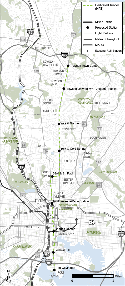
Alternative 4
Heavy Rail Transit (Subway) from Towson to Port Covington, via York Road/ Greenmount Avenue
DESCRIPTION
Alternative 4 is a Heavy Rail Transit (HRT) line between Towson and Port Covington via Towson University and Penn Station. The alignment begins at Towson and follows York Road before heading west following 33rd Street to then follow St. Paul Street, terminating at Port Covington. This alternative travels in exclusive right-of-way in below-grade tunnels for the entire length.
Key Characteristics
|
Heavy Rail Transit |
|
10.5 miles |
|
9 stations |
 |
Only Heavy Rail Transit Alternative |
 |
Greatest reliability with 100% of dedicated or separated guideway |
|
Fewest number of stations |
 |
Shortest travel time |
Areas Served
|
Lutherville |
|
Towson |
|
Towson University/St. Joseph's Med. Ctr |
|
Hillendale |
|
Belvedere Square |
|
Govans |
|
Good Samaritan Hospital |
|
Northwood |
|
Waverly |
|
Johns Hopkins University |
|
North & Greenmount |
|
Penn Station |
|
Midtown/UB |
|
Old Town |
|
Mt. Vernon |
|
Charles Center |
|
University of Maryland Medical Center |
|
Inner Harbor |
|
Harbor East |
|
Port Covington |
|
Theme |
Measure of Effectiveness |
Values |
Comparison |
|
Reliability |
Percent of dedicated or separated guideway |
100% |
BEST |
|
Fixed or Flexible Guideway |
FIXED |
FIXED |
|
|
Travel Time Savings |
Transit travel time savings between Towson and Downtown Baltimore (minutes) |
14 |
BEST |
|
Access |
Households within 1/2 mile of a station, per mile |
2,800 |
GOOD |
|
Student population within 1/2 mile of a station per mile |
500 |
GOOD |
|
|
Future jobs within 1/2 mile of a station per mile |
19,400 |
GOOD |
|
|
Connections |
Connections to rail stations, frequent bus routes, and locally operated transit routes |
19 |
GOOD |
|
Additional future jobs accessible by transit within 45 minutes |
6,000 |
GOOD |
|
|
Equity 1 |
All transit-critical populations within 1/2 mile of a station, per mile |
6,700 |
GOOD |
|
Cost |
Capital cost ($ millions) |
6,200 |
$$$ |
|
Development Opportunity |
Transit-Oriented Development and Opportunity Zones within 1/2 mile of station (acres) |
1,100 |
GOOD |
|
Implementation |
Implementation time (years) |
10-12 |
LONGEST |
|
Bridge and Tunnel Complexity |
High |
HIGH |
|
|
Ridership |
Projected daily boardings in 2045, per mile |
1,100 |
GOOD |
|
Sustainability |
Zero-car households within ½ mile of a station, per mile |
700 |
GOOD |
1 Sum of low-income, minority, limited English proficiency, and 65+ populations, people with disabilities, and zero-car households within 1/2 mile of a station, per mile. People/households may be counted more than once if they're part of multiple transit-critical groups.
Alternative 5
Bus Rapid Transit from Towson to Port Covington, via York Road/ Greenmount Avenue
DESCRIPTION
Alternative 5 is a Bus Rapid Transit (BRT) line between Towson and Port Covington via York Road and Penn Station. This alignment begins at Townson and travels along York and Greenmount Roads before connecting west on 33rd Street to join St. Paul and Charles Streets one-way pair to terminate at Port Covington. This alternative travels entirely on surface streets and operates almost exclusively in dedicated guideway, with limited mixed-traffic downtown near the Inner Harbor and beneath the I-95 viaduct.
Key Characteristics
|
Bus Rapid Transit |
|
10.4 miles |
|
30 stations |
|
Similar alignment to Alternative 4 (HRT) |
 |
Highest projected daily boardings in 2045, per mile |
Areas Served
|
Lutherville |
|
Towson |
|
Towson University/St. Joseph's Med. Ctr |
|
Hillendale |
|
Belvedere Square |
|
Govans |
|
Good Samaritan Hospital |
|
Northwood |
|
Waverly |
|
Johns Hopkins University |
|
North & Greenmount |
|
Penn Station |
|
Midtown/UB |
|
Old Town |
|
Mt. Vernon |
|
Charles Center |
|
University of Maryland Medical Center |
|
Inner Harbor |
|
Harbor East |
|
Port Covington |
|
Theme |
Measure of Effectiveness |
Values |
Comparison |
|
Reliability |
Percent of dedicated or separated guideway |
97% |
BETTER |
|
Fixed or Flexible Guideway |
FLEXIBLE |
FLEXIBLE |
|
|
Travel Time Savings |
Transit travel time savings between Towson and Downtown Baltimore (minutes) |
7 |
BETTER |
|
Access |
Households within 1/2 mile of a station, per mile |
4,500 |
BEST |
|
Student population within 1/2 mile of a station per mile |
1,000 |
BEST |
|
|
Future jobs within 1/2 mile of a station per mile |
24,500 |
BETTER |
|
|
Connections |
Connections to rail stations, frequent bus routes, and locally operated transit routes |
21 |
GOOD |
|
Additional future jobs accessible by transit within 45 minutes |
8,000 |
BETTER |
|
|
Equity 1 |
All transit-critical populations within 1/2 mile of a station, per mile |
11,900 |
BETTER |
|
Cost |
Capital cost ($ millions) |
600 |
$ |
|
Development Opportunity |
Transit-Oriented Development and Opportunity Zones within 1/2 mile of station (acres) |
1,400 |
BEST |
|
Implementation |
Implementation time (years) |
6-8 |
SHORTEST |
|
Bridge and Tunnel Complexity |
N/A |
N/A |
|
|
Ridership |
Projected daily boardings in 2045, per mile |
2,200 |
BEST |
|
Sustainability |
Zero-car households within ½ mile of a station, per mile |
1,300 |
BETTER |
1 Sum of low-income, minority, limited English proficiency, and 65+ populations, people with disabilities, and zero-car households within 1/2 mile of a station, per mile. People/households may be counted more than once if they're part of multiple transit-critical groups.
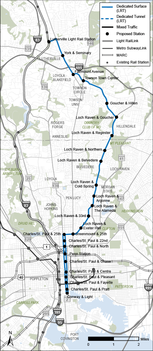
Alternative 6
Light Rail Transit from Lutherville to Otterbein, via Goucher Boulevard, Loch Raven Boulevard
DESCRIPTION
Alternative 6 is a Light Rail Transit (LRT) line between the Lutherville Light Rail Station and the Inner Harbor via Loch Raven Boulevard and Penn Station. The alignment starts at Lutherville Light Rail Station and continues southeast on Goucher Boulevard to Loch Raven Boulevard, continuing south to 25th Street to connect to the St. Paul/Charles Streets one-way pair to terminate in Downtown in Otterbein. This alternative travels entirely on surface streets and operates exclusively in dedicated guideway.
Key Characteristics
|
Light Rail Transit |
|
12.5 miles |
|
25 stations |
 |
Connects Lutherville, Towson, Downtown, and Inner Harbor via Loch Raven |
Areas Served
|
Lutherville |
|
Towson |
|
Towson University/St. Joseph's Med. Ctr |
|
Hillendale |
|
Belvedere Square |
|
Govans |
|
Good Samaritan Hospital |
|
Northwood |
|
Waverly |
|
Johns Hopkins University |
|
North & Greenmount |
|
Penn Station |
|
Midtown/UB |
|
Old Town |
|
Mt. Vernon |
|
Charles Center |
|
University of Maryland Medical Center |
|
Inner Harbor |
|
Harbor East |
|
Port Covington |
|
Theme |
Measure of Effectiveness |
Values |
Comparison |
|
Reliability |
Percent of dedicated or separated guideway |
98% |
BETTER |
|
Fixed or Flexible Guideway |
FIXED |
FIXED |
|
|
Travel Time Savings |
Transit travel time savings between Towson and Downtown Baltimore (minutes) |
3 |
GOOD |
|
Access |
Households within 1/2 mile of a station, per mile |
3,800 |
BETTER |
|
Student population within 1/2 mile of a station per mile |
900 |
GOOD |
|
|
Future jobs within 1/2 mile of a station per mile |
18,200 |
BETTER |
|
|
Connections |
Connections to rail stations, frequent bus routes, and locally operated transit routes |
23 |
BETTER |
|
Additional future jobs accessible by transit within 45 minutes |
11,000 |
GOOD |
|
|
Equity 1 |
All transit-critical populations within 1/2 mile of a station, per mile |
11,600 |
BETTER |
|
Cost |
Capital cost ($ millions) |
1,300 |
$$ |
|
Development Opportunity |
Transit-Oriented Development and Opportunity Zones within 1/2 mile of station (acres) |
1,200 |
BETTER |
|
Implementation |
Implementation time (years) |
7-9 |
MIDDLE |
|
Bridge and Tunnel Complexity |
Medium |
MEDIUM |
|
|
Ridership |
Projected daily boardings in 2045, per mile |
1,400 |
BETTER |
|
Sustainability |
Zero-car households within ½ mile of a station, per mile |
1,100 |
BETTER |
1 Sum of low-income, minority, limited English proficiency, and 65+ populations, people with disabilities, and zero-car households within 1/2 mile of a station, per mile. People/households may be counted more than once if they're part of multiple transit-critical groups.
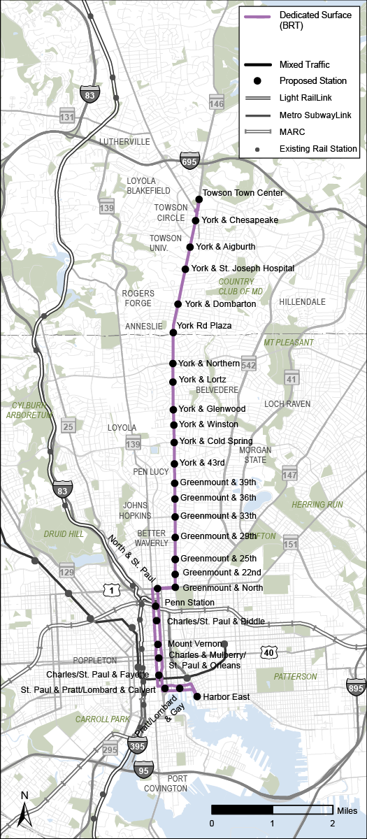
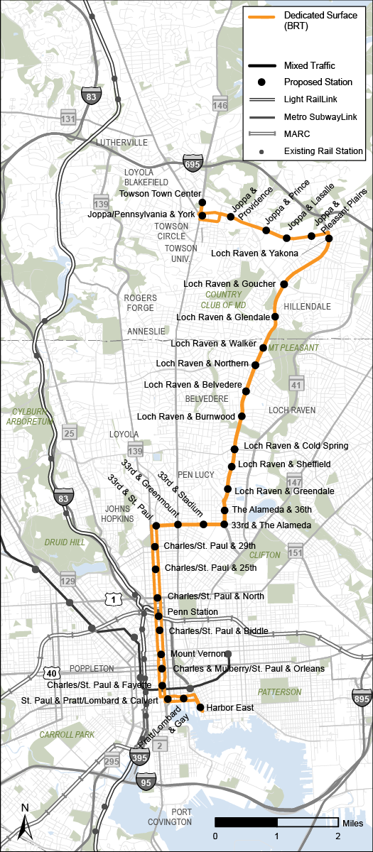
Alternative 7
Bus Rapid Transit from Towson to Harbor East, via Joppa Road, Loch Raven Boulevard
DESCRIPTION
Alternative 7 is a Bus Rapid Transit (BRT) line between Towson and the Inner Harbor via Loch Raven Boulevard. The alignment begins at Towson and travels along Joppa Road to connect with Loch Raven Boulevard to 33rd Street, then using the St Paul/Charles Streets one-way pair to terminate at Harbor East. This alternative travels entirely on surface streets and operates exclusively in dedicated guideway. It is the longest alternative and has the greatest number of stations.
Key Characteristics
|
Bus Rapid Transit |
|
12.6 miles |
|
32 stations |
|
Provides access to the largest number of transit-critical populations overall |
|
Only alternative to serve the Joppa/Loch Raven area |
Areas Served
|
Lutherville |
|
Towson |
|
Towson University/St. Joseph's Med. Ctr |
|
Hillendale |
|
Belvedere Square |
|
Govans |
|
Good Samaritan Hospital |
|
Northwood |
|
Waverly |
|
Johns Hopkins University |
|
North & Greenmount |
|
Penn Station |
|
Midtown/UB |
|
Old Town |
|
Mt. Vernon |
|
Charles Center |
|
University of Maryland Medical Center |
|
Inner Harbor |
|
Harbor East |
|
Port Covington |
|
Theme |
Measure of Effectiveness |
Values |
Comparison |
|
Reliability |
Percent of dedicated or separated guideway |
100% |
BEST |
|
Fixed or Flexible Guideway |
FLEXIBLE |
FLEXIBLE |
|
|
Travel Time Savings |
Transit travel time savings between Towson and Downtown Baltimore (minutes) |
0 |
GOOD |
|
Access |
Households within 1/2 mile of a station, per mile |
4,300 |
BETTER |
|
Student population within 1/2 mile of a station per mile |
1,000 |
BETTER |
|
|
Future jobs within 1/2 mile of a station per mile |
21,000 |
BETTER |
|
|
Connections |
Connections to rail stations, frequent bus routes, and locally operated transit routes |
22 |
GOOD |
|
Additional future jobs accessible by transit within 45 minutes |
22,000 |
GOOD |
|
|
Equity 1 |
All transit-critical populations within 1/2 mile of a station, per mile |
13,000 |
BETTER |
|
Cost |
Capital cost ($ millions) |
600 |
$ |
|
Development Opportunity |
Transit-Oriented Development and Opportunity Zones within 1/2 mile of station (acres) |
1,200 |
BETTER |
|
Implementation |
Implementation time (years) |
6-8 |
SHORTEST |
|
Bridge and Tunnel Complexity |
N/A |
N/A |
|
|
Ridership |
Projected daily boardings in 2045, per mile |
1,400 |
BETTER |
|
Sustainability |
Zero-car households within ½ mile of a station, per mile |
1,200 |
BEST |
1 Sum of low-income, minority, limited English proficiency, and 65+ populations, people with disabilities, and zero-car households within 1/2 mile of a station, per mile. People/households may be counted more than once if they're part of multiple transit-critical groups.