< Back to East-West Corridor Overview
EXPLORE EACH ALTERNATIVE
Select an alternative profile to view
< Back to East-West Corridor Overview
Select an alternative profile to view
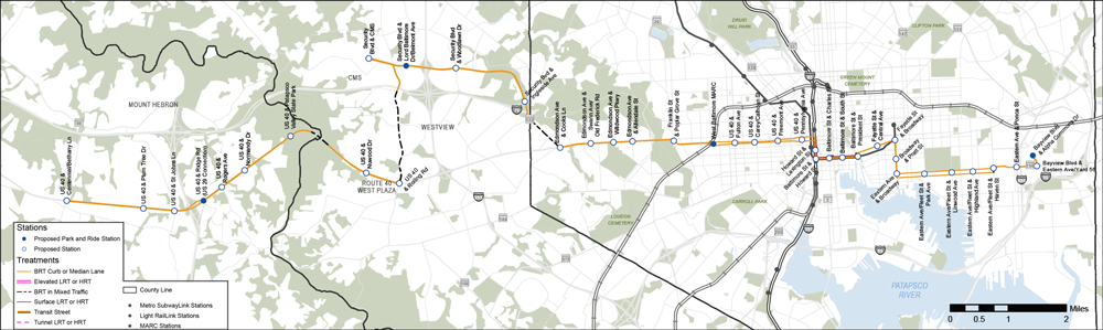
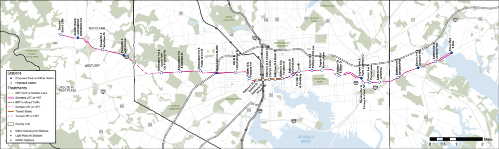
Alternative 1 is a Bus Rapid Transit (BRT) line between the Johns Hopkins Bayview campus and Ellicott City via Johns Hopkins Hospital and CMS. This alignment travels through Southeast Baltimore, Downtown Baltimore, West Baltimore, Woodlawn, Catonsville, and Ellicott City. This alternative travels entirely on surface streets, including Eastern Avenue and Fleet Street through Canton and Fells Point. It is the longest alternative being evaluated.
| THEME | MEASURE OF EFFECTIVENESS | VALUES | COMPARISON |
|---|---|---|---|
| Reliability | Percent of dedicated or separated guideway | 84% | GOOD |
| Fixed or Flexible Guideway | FLEXIBLE | FLEXIBLE | |
| System Travel Savings | Average travel time savings for transit riders living in the corridor | 2 minutes | GOOD |
| Travel Time | Transit travel time between West Baltimore and Hopkins Bayview1 | 54 minutes | GOOD |
| Ridership | Projected daily boardings in 2045 per mile | 1,100 | GOOD |
| Connections | Connections to rail stations, frequent bus routes and locally operated transit systems | 24 | BEST |
| Access | To households within 1/2 mile of a station, per mile | 2,600 | BETTER |
| To students within 1/2 mile of a station, per mile | 800 | GOOD | |
| To future jobs within 1/2 mile of a station, per mile | 11,500 | GOOD | |
| Equity | Transit-critical population / households within 1/2 mile of a station, per mile2 | 8,500 | GOOD |
| Sustainability | Trips shifted to transit | 4,700 | BEST |
| Cost | Capital cost | $1.1 Billion | $ |
| Implementation | Implementation time | 6-8 years | SHORTEST |
| Tunneling Complexity | N/A | N/A |
1 Total trip time, including walking to and from station. Baseline is currently 66 minutes.
2 Sum of low-income, minority, limited English proficiency, and 65+ populations, people with disabilities, and zero-car households within 1/2 mile of a station, per mile. People/households may be counted more than once if they're part of multiple transit-critical groups.
 |
Bus Rapid Transit (BRT) |
 |
22.7 miles |
 |
39 stations |
 |
Only alternative that serves both CMS and Ellicott City |
 |
Longest alternative with most stations |
 |
Includes a transit street along Howard and Baltimore Streets in Downtown Baltimore |
 |
Essex |
 |
Bayview |
|
Highlandtown |
|
Canton |
|
Fells Point / Harbor East |
|
McElderry Park |
|
Hopkins Hospital |
|
Old Town |
|
Inner Harbor |
|
Charles Center |
|
Lexington Market |
|
UM BioPark |
|
Harlem Park |
|
West Baltimore MARC |
|
Edmondson Village |
|
Woodlawn |
|
Ellicott City |
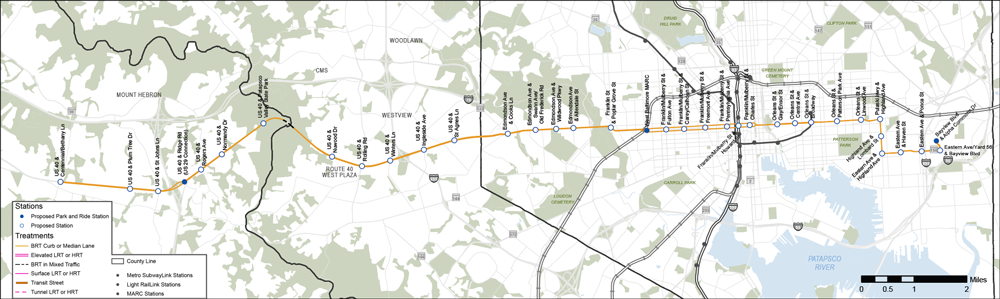
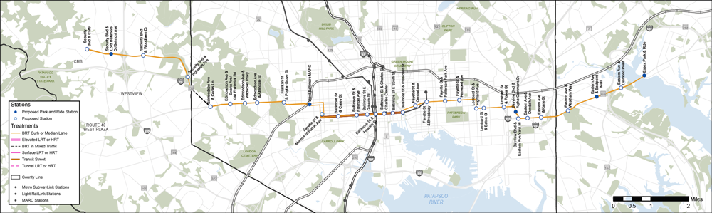
Alternative 2 is a Bus Rapid Transit (BRT) line between the Johns Hopkins Bayview campus and Ellicott City via Johns Hopkins Hospital and US 40. This alignment travels through East Baltimore, Downtown Baltimore, West Baltimore, Catonsville, and Ellicott City. This alternative travels entirely on surface streets, including Eastern Avenue, Highland Avenue, and Orleans Street through East Baltimore.
| THEME | MEASURE OF EFFECTIVENESS | VALUES | COMPARISON |
|---|---|---|---|
| Reliability | Percent of dedicated or separated guideway | 95% | BETTER |
| Fixed or Flexible Guideway | FLEXIBLE | FLEXIBLE | |
| System Travel Savings | Average travel time savings for transit riders living in the corridor | 2 minutes | GOOD |
| Travel Time | Transit travel time between West Baltimore and Hopkins Bayview1 | 52 minutes | GOOD |
| Ridership | Projected daily boardings in 2045 per mile | 1,100 | GOOD |
| Connections | Connections to rail stations, frequent bus routes and locally operated transit systems | 18 | GOOD |
| Access | To households within 1/2 mile of a station, per mile | 3,100 | BEST |
| To students within 1/2 mile of a station, per mile | 1,200 | BEST | |
| To future jobs within 1/2 mile of a station, per mile | 11,900 | GOOD | |
| Equity | Transit-critical population / households within 1/2 mile of a station, per mile2 | 11,600 | BEST |
| Sustainability | Trips shifted to transit | 4,800 | BEST |
| Cost | Capital cost | $1 Billion | $ |
| Implementation | Implementation time | 6-8 years | SHORTEST |
| Tunneling Complexity | N/A | N/A |
1 Total trip time, including walking to and from station. Baseline is currently 66 minutes.
2 Sum of low-income, minority, limited English proficiency, and 65+ populations, people with disabilities, and zero-car households within 1/2 mile of a station, per mile. People/households may be counted more than once if they're part of multiple transit-critical groups.
|
Bus Rapid Transit (BRT) |
|
18.4 miles |
|
36 stations |
 |
Connects Bayview to Howard County via a direct route along US 40 |
 |
Provides a connection between Bayview and Johns Hopkins Hospital north of Patterson Park |
|
Essex |
|
Bayview |
|
Highlandtown |
|
Canton |
|
Fells Point / Harbor East |
|
McElderry Park |
|
Hopkins Hospital |
|
Old Town |
|
Inner Harbor |
|
Charles Center |
|
Lexington Market |
|
UM BioPark |
|
Harlem Park |
|
West Baltimore MARC |
|
Edmondson Village |
|
Woodlawn |
|
Ellicott City |
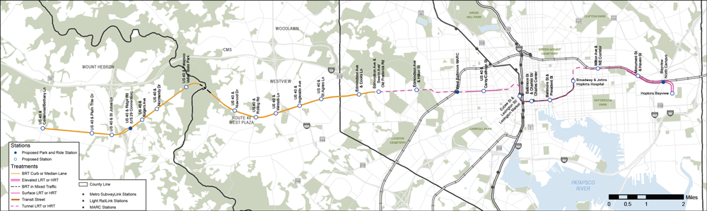
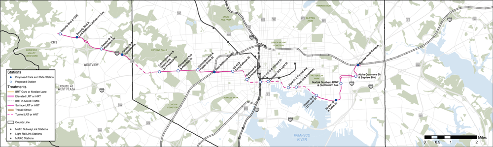
Alternative 3 is a combination of a Heavy Rail Transit (HRT) line, known as Metro Subway in Baltimore, between the Johns Hopkins Bayview campus and Edmondson Village via Johns Hopkins Hospital, and a Bus Rapid Transit (BRT) line between Edmondson Village and Ellicott City. This alignment travels through East Baltimore, Downtown Baltimore, West Baltimore, Catonsville, and Ellicott City. The HRT section of the alternative travels in exclusive right-of-way, mostly in tunnels or on elevated structures, making use of the existing Metro Subway tunnel and stations between Johns Hopkins Hospital and Lexington Market. The BRT section of the alternative travels entirely on surface streets.
| THEME | MEASURE OF EFFECTIVENESS | VALUES | COMPARISON |
|---|---|---|---|
| Reliability | Percent of dedicated or separated guideway | 95% | BETTER |
| Fixed or Flexible Guideway | FLEXIBLE/ FIXED | FLEXIBLE/ FIXED | |
| System Travel Savings | Average travel time savings for transit riders living in the corridor | 2 minutes | GOOD |
| Travel Time | Transit travel time between West Baltimore and Hopkins Bayview1 | 39 minutes | BEST |
| Ridership | Projected daily boardings in 2045 per mile | 1,400 | BETTER |
| Connections | Connections to rail stations, frequent bus routes and locally operated transit systems | 21 | BETTER |
| Access | To households within 1/2 mile of a station, per mile | 2,300 | GOOD |
| To students within 1/2 mile of a station, per mile | 1,000 | BETTER | |
| To future jobs within 1/2 mile of a station, per mile | 12,000 | GOOD | |
| Equity | Transit-critical population / households within 1/2 mile of a station, per mile2 | 9,300 | GOOD |
| Sustainability | Trips shifted to transit | 2,800 | GOOD |
| Cost | Capital cost | $4.2 Billion | $$$$ |
| Implementation | Implementation time | 10-12 years | LONGEST |
| Tunneling Complexity | HIGH | HIGH |
1 Total trip time, including walking to and from station. Baseline is currently 66 minutes.
2 Sum of low-income, minority, limited English proficiency, and 65+ populations, people with disabilities, and zero-car households within 1/2 mile of a station, per mile. People/households may be counted more than once if they're part of multiple transit-critical groups.
 |
Heavy Rail Transit (HRT) |
|
Bus Rapid Transit (LRT) |
|
19.1 miles |
|
25 stations |
|
Only alternative to serve neighborhoods northeast of Hopkins Hospital |
|
Only alternative that includes Heavy Rail Transit (HRT) in the densest parts of the study area |
 |
Utilizes existing Metro Subway infrastructure between Johns Hopkins Hospital and Lexington Market |
|
Essex |
|
Bayview |
|
Highlandtown |
|
Canton |
|
Fells Point / Harbor East |
|
McElderry Park |
|
Hopkins Hospital |
|
Old Town |
|
Inner Harbor |
|
Charles Center |
|
Lexington Market |
|
UM BioPark |
|
Harlem Park |
|
West Baltimore MARC |
|
Edmondson Village |
|
Woodlawn |
|
Ellicott City |
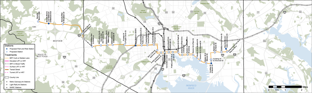
Alternative 4 is a Light Rail Transit (LRT) line between Essex and the Centers for Medicare & Medicaid Services (CMS) campus via the Johns Hopkins Bayview campus and Johns Hopkins Hospital. This alignment travels through Eastpoint, East Baltimore, Downtown Baltimore, West Baltimore, and Woodlawn. This alternative travels mostly on surface streets, with a short tunnel under Highlandtown in East Baltimore and a short tunnel under Cooks Lane in West Baltimore.
| THEME | MEASURE OF EFFECTIVENESS | VALUES | COMPARISON |
|---|---|---|---|
| Reliability | Percent of dedicated or separated guideway | 92% | BETTER |
| Fixed or Flexible Guideway | FIXED | FIXED | |
| System Travel Savings | Average travel time savings for transit riders living in the corridor | 4 minutes | BEST |
| Travel Time | Transit travel time between West Baltimore and Hopkins Bayview1 | 47 minutes | BETTER |
| Ridership | Projected daily boardings in 2045 per mile | 1,400 | BETTER |
| Connections | Connections to rail stations, frequent bus routes and locally operated transit systems | 21 | BETTER |
| Access | To households within 1/2 mile of a station, per mile | 2,700 | BETTER |
| To students within 1/2 mile of a station, per mile | 1,000 | BETTER | |
| To future jobs within 1/2 mile of a station per mile | 14,700 | BETTER | |
| Equity | Transit-critical population / households within 1/2 mile of a station per mile2 | 10,900 | BETTER |
| Sustainability | Trips shifted to transit | 1,700 | GOOD |
| Cost | Capital cost | $3.1 Billion | $$$ |
| Implementation | Implementation time | 8-10 years | MIDDLE |
| Tunneling Complexity | MEDIUM | MEDIUM |
1 Total trip time, including walking to and from station. Baseline is currently 66 minutes.
2 Sum of low-income, minority, limited English proficiency, and 65+ populations, people with disabilities, and zero-car households within 1/2 mile of a station, per mile. People/households may be counted more than once if they're part of multiple transit-critical groups.
 |
Light Rail Transit (LRT) |
|
16.4 miles |
|
28 stations |
 |
Similar alignment to Alternative 5 (BRT) |
 |
Only LRT alternative that travels north of Patterson Park |
|
Includes a connection between Essex and Bayview |
|
Includes a transit-only street along Baltimore Street in Downtown Baltimore |
|
Essex |
|
Bayview |
|
Highlandtown |
|
Canton |
|
Fells Point / Harbor East |
|
McElderry Park |
|
Hopkins Hospital |
|
Old Town |
|
Inner Harbor |
|
Charles Center |
|
Lexington Market |
|
UM BioPark |
|
Harlem Park |
|
West Baltimore MARC |
|
Edmondson Village |
|
Woodlawn |
|
Ellicott City |
Alternative 5 is a Bus Rapid Transit (BRT) line between Essex and the Centers for Medicare & Medicaid Services (CMS) campus via the Johns Hopkins Bayview campus and Johns Hopkins Hospital. This alignment travels through Eastpoint, East Baltimore, Downtown Baltimore, West Baltimore, and Woodlawn. This alternative travels exclusively on surface streets.
| THEME | MEASURE OF EFFECTIVENESS | VALUES | COMPARISON |
|---|---|---|---|
| Reliability | Percent of dedicated or separated guideway | 94% | BETTER |
| Fixed or Flexible Guideway | FLEXIBLE | FLEXIBLE | |
| System Travel Savings | Average travel time savings for transit riders living in the corridor | 2 minutes | BETTER |
| Travel Time | Transit travel time between West Baltimore and Hopkins Bayview1 | 51 minutes | GOOD |
| Ridership | Projected daily boardings in 2045 per mile | 1,400 | BETTER |
| Connections | Connections to rail stations, frequent bus routes and locally operated transit systems | 21 | BETTER |
| Access | To households within 1/2 mile of station, per mile | 2,700 | BETTER |
| To students within 1/2 mile of a station, per mile | 1,000 | BETTER | |
| To future jobs within 1/2 mile of a station per mile | 14,000 | BETTER | |
| Equity | Transit-critical population / households within 1/2 mile of a station per mile2 | 10,700 | BETTER |
| Sustainability | Trips shifted to transit | 3,100 | BETTER |
| Cost | Capital cost | $0.9 Billion | $ |
| Implementation | Implementation time | 6-8 years | SHORTEST |
| Tunneling Complexity | N/A | N/A |
1 Total trip time, including walking to and from station. Baseline is currently 66 minutes.
2 Sum of low-income, minority, limited English proficiency, and 65+ populations, people with disabilities, and zero-car households within 1/2 mile of a station, per mile. People/households may be counted more than once if they're part of multiple transit-critical groups.
|
Bus Rapid Transit (BRT) |
|
17.1 miles |
|
33 stations |
|
Similar alignment to Alternative 4 (LRT) |
|
BRT alternative that travels north of Patterson Park |
|
Includes a connection between Essex and Bayview |
|
Includes a transit-only street along Baltimore Street in Downtown Baltimore and West Baltimore |
|
Essex |
|
Bayview |
|
Highlandtown |
|
Canton |
|
Fells Point / Harbor East |
|
McElderry Park |
|
Hopkins Hospital |
|
Old Town |
|
Inner Harbor |
|
Charles Center |
|
Lexington Market |
|
UM BioPark |
|
Harlem Park |
|
West Baltimore MARC |
|
Edmondson Village |
|
Woodlawn |
|
Ellicott City |
Alternative 6 is a Light Rail Transit (LRT) line between the Johns Hopkins Bayview campus and the Centers for Medicare & Medicaid Services (CMS) campus via the waterfront. This alignment travels through the Southeast Baltimore waterfront, Harbor East, the Inner Harbor, West Baltimore, and Woodlawn. It travels mostly on surface roads, with a long tunnel through downtown Baltimore and a short tunnel in far West Baltimore.
| THEME | MEASURE OF EFFECTIVENESS | VALUES | COMPARISON |
|---|---|---|---|
| Reliability | Percent of dedicated or separated guideway | 100% | BEST |
| Fixed or Flexible Guideway | FIXED | FIXED | |
| System Travel Savings | Average travel time savings for transit riders living in the corridor | 3 minutes | BEST |
| Travel Time | Transit travel time between West Baltimore and Hopkins Bayview1 | 44 minutes | BEST |
| Ridership | Projected daily boardings in 2045 per mile | 1,900 | BEST |
| Connections | Connections to rail stations, frequent bus routes and locally operated transit systems | 22 | BETTER |
| Access | To households within 1/2 mile of a station, per mile | 3,000 | BEST |
| To students within 1/2 mile of a station, per mile | 900 | GOOD | |
| To future jobs within 1/2 mile of a station per mile | 15,500 | BEST | |
| Equity | Transit-critical population / households within 1/2 mile of a station per mile2 | 9,800 | GOOD |
| Sustainability | Trips shifted to transit | 3,000 | BETTER |
| Cost | Capital cost | $3.8 Billion | $$$ |
| Implementation | Implementation time | 7-9 years | MIDDLE |
| Tunneling Complexity | HIGH | HIGH |
1 Total trip time, including walking to and from station. Baseline is currently 66 minutes.
2 Sum of low-income, minority, limited English proficiency, and 65+ populations, people with disabilities, and zero-car households within 1/2 mile of a station, per mile. People/households may be counted more than once if they're part of multiple transit-critical groups.
|
Light Rail Transit (LRT) |
|
14.1 miles |
|
19 stations |
|
Similar alignment to Alternative 7 (BRT) |
|
Essex |
|
Bayview |
|
Highlandtown |
|
Canton |
|
Fells Point / Harbor East |
|
McElderry Park |
|
Hopkins Hospital |
|
Old Town |
|
Inner Harbor |
|
Charles Center |
|
Lexington Market |
|
UM BioPark |
|
Harlem Park |
|
West Baltimore MARC |
|
Edmondson Village |
|
Woodlawn |
|
Ellicott City |
Alternative 7 is a Bus Rapid Transit (BRT) line between the Johns Hopkins Bayview campus and the Centers for Medicare & Medicaid Services (CMS) campus via the waterfront. This alignment travels through the Southeast Baltimore waterfront, Harbor East, the Inner Harbor, West Baltimore, and Woodlawn. This alternative is similar to Alternative 6, but travels exclusively on surface streets.
| THEME | MEASURE OF EFFECTIVENESS | VALUES | COMPARISON |
|---|---|---|---|
| Reliability | Percent of dedicated or separated guideway | 93% | BETTER |
| Fixed or Flexible Guideway | FLEXIBLE | FLEXIBLE | |
| System Travel Savings | Average travel time savings for transit riders living in the corridor | 2 minutes | GOOD |
| Travel Time | Transit travel time between West Baltimore and Hopkins Bayview1 | 57 minutes | GOOD |
| Ridership | Projected daily boardings in 2045 per mile | 1,500 | BETTER |
| Connections | Connections to rail stations, frequent bus routes and locally operated transit systems | 22 | BETTER |
| Access | To households within 1/2 mile of a station, per mile | 3,200 | BEST |
| To students within 1/2 mile of a station, per mile | 1,000 | BETTER | |
| To future jobs within 1/2 mile of a station per mile | 15,700 | BEST | |
| Equity | Transit-critical population / households within 1/2 mile of a station per mile2 | 10,700 | BETTER |
| Sustainability | Trips shifted to transit | 3,000 | BETTER |
| Cost | Capital cost | $0.8 Billion | $ |
| Implementation | Implementation time | 5-7 years | SHORTEST |
| Tunneling Complexity | N/A | N/A |
1 Total trip time, including walking to and from station. Baseline is currently 66 minutes.
2 Sum of low-income, minority, limited English proficiency, and 65+ populations, people with disabilities, and zero-car households within 1/2 mile of a station, per mile. People/households may be counted more than once if they're part of multiple transit-critical groups.
|
Bus Rapid Transit (BRT) |
|
14.2 miles |
|
31 stations |
|
Similar alignment to Alternative 6 (LRT) |
|
Essex |
|
Bayview |
|
Highlandtown |
|
Canton |
|
Fells Point / Harbor East |
|
McElderry Park |
|
Hopkins Hospital |
|
Old Town |
|
Inner Harbor |
|
Charles Center |
|
Lexington Market |
|
UM BioPark |
|
Harlem Park |
|
West Baltimore MARC |
|
Edmondson Village |
|
Woodlawn |
|
Ellicott City |
![]()
Thanks for your interest in the RTP East-West Corridor Study! The 60 day public comment period ended August 1st, and MDOT MTA and our regional partners are now using what has been shared to help determine which Alternatives (or combination of Alternatives) receive further study. You are always welcome to share additional thoughts by emailing us, but they won’t be factored into this phase of study.